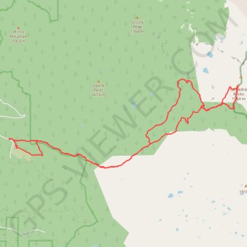
Cathedral Rocks Loop via Bingham Ridge
Interactive trail map
Trail profile
- Distance: 16.3 mi
- Elevation gain: 3,209 ft
- Maximum elevation: 6,253 ft
- Elevation loss: 3,209 ft
- Minimum elevation: 4,239 ft
About this trail
Name: Cathedral Rocks Loop via Bingham Ridge trail, distance, elevation, map, profile, GPS track
Start: Forest Road 2253, Linn County, Oregon, United States (44.60582 -121.90930)
End: Forest Road 2253, Linn County, Oregon, United States (44.60584 -121.90930)
Coordinates: 44.59687 -121.90936 44.62461 -121.80923
Topography: Linn County topographic map, elevation, terrain
Other hiking, mountain biking, running and outdoor activity trails
Click on a trail to view its statistics, map and profile.
Northern part of the Pacific Crest Trail (PCT)
United States > Oregon > Klamath County
Hike on the Pacific Crest National Scenic Trail from Crater Lake to Canada Border through Oregon and Washington along the Sierra Nevada and Cascade mountain ranges. #Hiking #Mountain #SierraNevada #Cascade #Nature #Forest #Park #PCT
Distance: 744.6 mi • Elevation gain: 145,367 ft • Maximum elevation: 7,569 ft