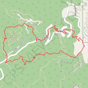
Flagstaff Mountain Loop via Gregory Canyon Trail, Range View Trail and Flagstaff Trail
The Flagstaff Mountain Loop offers a memorable hiking experience within Boulder’s iconic foothills. Along the route, hikers are treated to sweeping views of the Flatirons, the city of Boulder below, and lush forested areas, especially as the trail ascends towards Flagstaff Mountain. The diverse scenery transitions from rocky paths to alpine meadows, showcasing wildflowers in the warmer months, while wildlife sightings add to the adventure. #Hiking #Mountain #Loop #Forest #Nature
- Distance: 4.1 mi
- Elevation gain: 1,237 ft
- Maximum elevation: 6,946 ft
- Elevation loss: 1,253 ft
- Minimum elevation: 5,751 ft
- Moving time: 1 h 49 m
- Moving speed: 2.2 mph
- Maximum speed: 4.6 mph
- Total time: 2 h 13 m
- Global speed: 1.8 mph
Interactive trail map
Trail profile
About this trail
Name: Flagstaff Mountain Loop via Gregory Canyon Trail, Range View Trail and Flagstaff Trail trail, distance, elevation, map, profile, GPS track
Coordinates: 39.99601 -105.30994 40.00344 -105.29088
Topography: Boulder County topographic map, elevation, terrain
Other hiking, mountain biking, running and outdoor activity trails
Click on a trail to view its statistics, map and profile.
Green Mountain via Gregory Canyon Trail and Ranger Trail
United States > Colorado > Boulder County
The Green Mountain hike via Gregory Canyon and Ranger Trails offers a moderately challenging journey through varied terrain, with sweeping views of the Boulder Valley and surrounding peaks. Hikers will experience a mix of shaded forest paths, rocky ridgelines, and open meadows, culminating in panoramic vistas…
Distance: 2.8 mi • Elevation gain: 2,208 ft • Maximum elevation: 8,035 ft
Royal Arch via Bluebell Hiking Trail, Royal Arch Trail and The Flatirons
United States > Colorado > Boulder County > Boulder
The Royal Arch Trail in Boulder offers a rewarding hike that leads you through a scenic forest with glimpses of the iconic Flatirons. While the ascent involves quite a few stairs, the effort pays off when you reach the stunning Royal Arch, where you can soak in this impressive rock formation up close. #Hiking…
Distance: 3.6 mi • Elevation gain: 1,266 ft • Maximum elevation: 6,906 ft