Thank you for supporting this site ❤️
Make a donation
Make a donation
Gear up for your next adventure:
As an Amazon Associate, this site earns from qualifying purchases at no extra cost to you.
Blowhard Bush
- Distance: 2.9 mi
- Elevation gain: 561 ft
- Maximum elevation: 2,687 ft
- Elevation loss: 561 ft
- Minimum elevation: 2,310 ft
- Moving time: 1 h 9 m
- Moving speed: 2.5 mph
- Maximum speed: 12.1 mph
- Total time: 1 h 10 m
- Global speed: 2.5 mph
Interactive trail map
Thank you for supporting this site ❤️
Make a donation
Make a donation
Gear up for your next adventure:
As an Amazon Associate, this site earns from qualifying purchases at no extra cost to you.
Trail profile
- Distance: 2.9 mi
- Elevation gain: 561 ft
- Maximum elevation: 2,687 ft
- Elevation loss: 561 ft
- Minimum elevation: 2,310 ft
- Moving time: 1 h 9 m
- Moving speed: 2.5 mph
- Maximum speed: 12.1 mph
- Total time: 1 h 10 m
- Global speed: 2.5 mph
Thank you for supporting this site ❤️
Make a donation
Make a donation
Gear up for your next adventure:
As an Amazon Associate, this site earns from qualifying purchases at no extra cost to you.
About this trail
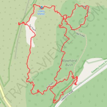
Name: Blowhard Bush trail, distance, elevation, map, profile, GPS track
Start: Tui Track, Hastings District, Hawke's Bay, New Zealand (-39.41412 176.41648)
End: Tui Track, Hastings District, Hawke's Bay, New Zealand (-39.41416 176.41635)
Coordinates: -39.41542 176.41111 -39.40846 176.41758
Thank you for supporting this site ❤️
Make a donation
Make a donation
Gear up for your next adventure:
As an Amazon Associate, this site earns from qualifying purchases at no extra cost to you.