Thank you for supporting this site ❤️
Make a donation
Make a donation
Gear up for your next adventure:
As an Amazon Associate, this site earns from qualifying purchases at no extra cost to you.
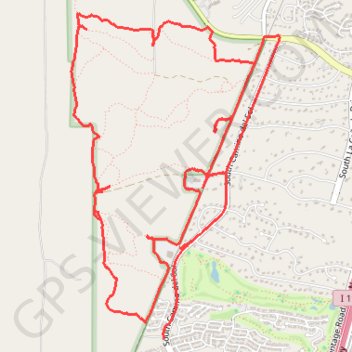
West Desert Trails
- Distance: 8.9 mi
- Elevation gain: 292 ft
- Maximum elevation: 3,140 ft
- Elevation loss: 338 ft
- Minimum elevation: 2,989 ft
- Moving time: 1 h 22 m
- Moving speed: 6.5 mph
- Maximum speed: 20.3 mph
- Total time: 1 h 46 m
- Global speed: 5.0 mph
Interactive trail map
Thank you for supporting this site ❤️
Make a donation
Make a donation
Gear up for your next adventure:
As an Amazon Associate, this site earns from qualifying purchases at no extra cost to you.
Trail profile
- Distance: 8.9 mi
- Elevation gain: 292 ft
- Maximum elevation: 3,140 ft
- Elevation loss: 338 ft
- Minimum elevation: 2,989 ft
- Moving time: 1 h 22 m
- Moving speed: 6.5 mph
- Maximum speed: 20.3 mph
- Total time: 1 h 46 m
- Global speed: 5.0 mph
Thank you for supporting this site ❤️
Make a donation
Make a donation
Gear up for your next adventure:
As an Amazon Associate, this site earns from qualifying purchases at no extra cost to you.
About this trail
Name: West Desert Trails trail, distance, elevation, map, profile, GPS track
End: South Camino del Sol, Green Valley, Pima County, Arizona, 85622, United States (31.85375 -111.00857)
Coordinates: 31.83180 -111.02573 31.85734 -111.00640
Topography: Pima County topographic map, elevation, terrain
Thank you for supporting this site ❤️
Make a donation
Make a donation
Gear up for your next adventure:
As an Amazon Associate, this site earns from qualifying purchases at no extra cost to you.