Thank you for supporting this site ❤️
Make a donation
Make a donation
Gear up for your next adventure:
As an Amazon Associate, this site earns from qualifying purchases at no extra cost to you.
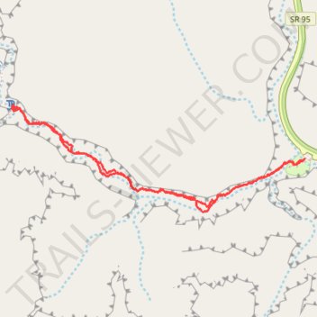
Hog Canyon Trail
- Distance: 2.3 mi
- Elevation gain: 446 ft
- Maximum elevation: 4,285 ft
- Elevation loss: 446 ft
- Minimum elevation: 4,104 ft
- Moving time: 58 m
- Moving speed: 2.4 mph
- Maximum speed: 3.9 mph
- Total time: 1 h 3 m
- Global speed: 2.2 mph
Interactive trail map
Thank you for supporting this site ❤️
Make a donation
Make a donation
Gear up for your next adventure:
As an Amazon Associate, this site earns from qualifying purchases at no extra cost to you.
Trail profile
- Distance: 2.3 mi
- Elevation gain: 446 ft
- Maximum elevation: 4,285 ft
- Elevation loss: 446 ft
- Minimum elevation: 4,104 ft
- Moving time: 58 m
- Moving speed: 2.4 mph
- Maximum speed: 3.9 mph
- Total time: 1 h 3 m
- Global speed: 2.2 mph
Thank you for supporting this site ❤️
Make a donation
Make a donation
Gear up for your next adventure:
As an Amazon Associate, this site earns from qualifying purchases at no extra cost to you.
About this trail
Name: Hog Canyon Trail trail, distance, elevation, map, profile, GPS track
Start: SR 95, Garfield County, Utah, United States (37.96264 -110.49140)
End: SR 95, Garfield County, Utah, United States (37.96266 -110.49134)
Coordinates: 37.96035 -110.50746 37.96498 -110.49134
Topography: Garfield County topographic map, elevation, terrain
Thank you for supporting this site ❤️
Make a donation
Make a donation
Gear up for your next adventure:
As an Amazon Associate, this site earns from qualifying purchases at no extra cost to you.