Make a donation
Gear up for your next adventure:
As an Amazon Associate, this site earns from qualifying purchases at no extra cost to you.
Mount Karkom - White Canyon
הר כרכום והקניון הלבן: סכין כרכום ואולי טבילה בקניון הלבן
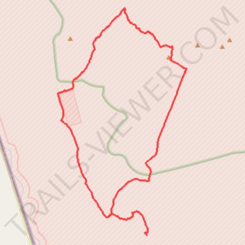
- Distance: 21.2 mi
- Elevation gain: 2,569 ft
- Maximum elevation: 2,700 ft
- Elevation loss: 2,569 ft
- Minimum elevation: 1,506 ft
- Moving time: 9 h 1 m
- Moving speed: 2.3 mph
- Maximum speed: 2.7 mph
- Total time: 9 h 1 m
- Global speed: 2.3 mph
Interactive trail map
Make a donation
Gear up for your next adventure:
As an Amazon Associate, this site earns from qualifying purchases at no extra cost to you.
Trail profile
- Distance: 21.2 mi
- Elevation gain: 2,569 ft
- Maximum elevation: 2,700 ft
- Elevation loss: 2,569 ft
- Minimum elevation: 1,506 ft
- Moving time: 9 h 1 m
- Moving speed: 2.3 mph
- Maximum speed: 2.7 mph
- Total time: 9 h 1 m
- Global speed: 2.3 mph
Make a donation
Gear up for your next adventure:
As an Amazon Associate, this site earns from qualifying purchases at no extra cost to you.
About this trail
Name: Mount Karkom - White Canyon trail, distance, elevation, map, profile, GPS track
Coordinates: 30.20905 34.68627 30.30933 34.75225
Make a donation
Gear up for your next adventure:
As an Amazon Associate, this site earns from qualifying purchases at no extra cost to you.
Other hiking, mountain biking, running and outdoor activity trails
Click on a trail to view its statistics, map and profile.
Karkom - Hispas
Israel > South District > Hevel Eilot Regional Council
הר כרכום להר חספס: מסלול 8 דרך באר כרכום ובלי מילה על הסנה הבוער
Distance: 17.8 mi • Elevation gain: 2,329 ft • Maximum elevation: 2,707 ft
Mount Arif - Mount Karkom
Israel > South District > Ramat Negev Regional Council
הר עריף להר כרכום: הכי מרוחק ופראי שיש
Distance: 21.5 mi • Elevation gain: 3,399 ft • Maximum elevation: 3,051 ft