Stromboli selbst
- Distance: 5.0 mi
- Elevation gain: 1,555 ft
- Maximum elevation: 1,017 ft
- Elevation loss: 1,611 ft
- Minimum elevation: 20 ft
- Moving time: 2 h 26 m
- Moving speed: 2.0 mph
- Maximum speed: 9.1 mph
- Total time: 5 h 33 m
- Global speed: 0.9 mph
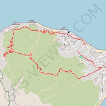
Interactive trail map
Trail profile
- Distance: 5.0 mi
- Elevation gain: 1,555 ft
- Maximum elevation: 1,017 ft
- Elevation loss: 1,611 ft
- Minimum elevation: 20 ft
- Moving time: 2 h 26 m
- Moving speed: 2.0 mph
- Maximum speed: 9.1 mph
- Total time: 5 h 33 m
- Global speed: 0.9 mph
About this trail
Name: Stromboli selbst trail, distance, elevation, map, profile, GPS track
Coordinates: 38.80082 15.21381 38.81084 15.23822