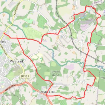
Walk - Scaynes Hill, Horsted Keynes, Lindfield
- Distance: 10.5 mi
- Elevation gain: 735 ft
- Maximum elevation: 282 ft
- Elevation loss: 735 ft
- Minimum elevation: 75 ft
- Moving time: 3 h 46 m
- Moving speed: 2.8 mph
- Maximum speed: 5.2 mph
- Total time: 4 h 47 m
- Global speed: 2.2 mph
Interactive trail map
Trail profile
- Distance: 10.5 mi
- Elevation gain: 735 ft
- Maximum elevation: 282 ft
- Elevation loss: 735 ft
- Minimum elevation: 75 ft
- Moving time: 3 h 46 m
- Moving speed: 2.8 mph
- Maximum speed: 5.2 mph
- Total time: 4 h 47 m
- Global speed: 2.2 mph
About this trail
Name: Walk - Scaynes Hill, Horsted Keynes, Lindfield trail, distance, elevation, map, profile, GPS track
Coordinates: 50.98983 -0.07852 51.02721 -0.01668
Other hiking, mountain biking, running and outdoor activity trails
Click on a trail to view its statistics, map and profile.
Walk - Danehill, Chelwood Gate, Birchgrove, Horsted Keynes
United Kingdom > England > East Sussex > Wealden > Danehill
Danehill, Chelwood Gate, Birchgrove, Horsted Keynes
Distance: 9.9 mi • Elevation gain: 1,129 ft • Maximum elevation: 515 ft
Walk - Danehill, Horsted Keynes
United Kingdom > England > East Sussex > Wealden > Danehill
Distance: 7.8 mi • Elevation gain: 745 ft • Maximum elevation: 387 ft
Loop Walk between Scaynes Hill and Horsted Keynes
United Kingdom > England > West Sussex > Mid Sussex > Scaynes Hill
Distance: 11.3 mi • Elevation gain: 840 ft • Maximum elevation: 328 ft
Loop Walk - Danehill, Chelwood Gate, Birchgrove, Horsted Keynes
United Kingdom > England > East Sussex > Wealden > Danehill
Distance: 11.1 mi • Elevation gain: 1,237 ft • Maximum elevation: 515 ft
Walk - Horsted Keynes, Danehill, Heaven Farm
United Kingdom > England > West Sussex > Mid Sussex > Horsted Keynes
Distance: 8.1 mi • Elevation gain: 925 ft • Maximum elevation: 410 ft
Walk between Scaynes Hill and Horsted Keynes
United Kingdom > England > West Sussex > Mid Sussex > Scaynes Hill
Distance: 9.8 mi • Elevation gain: 827 ft • Maximum elevation: 305 ft
Loop Walk - Scaynes Hill, Horsted Keynes
United Kingdom > England > West Sussex > Mid Sussex > Scaynes Hill
Distance: 11.1 mi • Elevation gain: 843 ft • Maximum elevation: 328 ft
Loop Walk - Scaynes Hill, Shefield Park
United Kingdom > England > West Sussex > Mid Sussex > Scaynes Hill
Distance: 10.5 mi • Elevation gain: 741 ft • Maximum elevation: 259 ft
Walk - Scaynes Hill, Horsted Keynes
United Kingdom > England > West Sussex > Mid Sussex > Scaynes Hill
Distance: 11.1 mi • Elevation gain: 850 ft • Maximum elevation: 328 ft