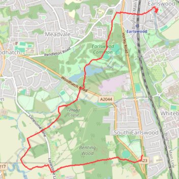
Walk - Petridgewood Common, Sidlow Bridge, Earlswood Common
- Distance: 4.2 mi
- Elevation gain: 194 ft
- Maximum elevation: 341 ft
- Elevation loss: 187 ft
- Minimum elevation: 171 ft
Interactive trail map
Trail profile
- Distance: 4.2 mi
- Elevation gain: 194 ft
- Maximum elevation: 341 ft
- Elevation loss: 187 ft
- Minimum elevation: 171 ft
About this trail
Name: Walk - Petridgewood Common, Sidlow Bridge, Earlswood Common trail, distance, elevation, map, profile, GPS track
Coordinates: 51.20805 -0.19547 51.23003 -0.16632
Other hiking, mountain biking, running and outdoor activity trails
Click on a trail to view its statistics, map and profile.
Loop Walk Earlswood, South Nutfield, Nutfield, Nutfield Marsh, Redhill
United Kingdom > England > Surrey > Reigate and Banstead > Redhill
Distance: 9.0 mi • Elevation gain: 522 ft • Maximum elevation: 476 ft
Walk Earlswood, Merstham, Chaldon church, Fartyhing Downs, Coulson
United Kingdom > England > Surrey > Reigate and Banstead > Redhill
Distance: 10.2 mi • Elevation gain: 817 ft • Maximum elevation: 646 ft
Walk Earlswood to Nutfield March, via South Nutfield
United Kingdom > England > Surrey > Reigate and Banstead > Redhill
Distance: 7.1 mi • Elevation gain: 404 ft • Maximum elevation: 476 ft
Walk Earlswood to Hooley
United Kingdom > England > Surrey > Reigate and Banstead > Redhill
South Merstham, Earlswood, Alderstead Heath, Netherne, Hooley
Distance: 7.7 mi • Elevation gain: 682 ft • Maximum elevation: 646 ft