Make a donation
Gear up for your next adventure:
As an Amazon Associate, this site earns from qualifying purchases at no extra cost to you.
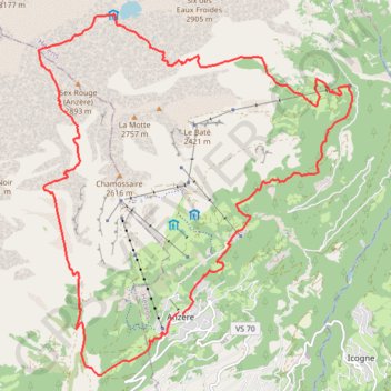
ANZERE_TRAIL DES AUDANNES
- Distance: 15.6 mi
- Elevation gain: 5,141 ft
- Maximum elevation: 8,940 ft
- Elevation loss: 5,177 ft
- Minimum elevation: 4,849 ft
Interactive trail map
Make a donation
Gear up for your next adventure:
As an Amazon Associate, this site earns from qualifying purchases at no extra cost to you.
Trail profile
- Distance: 15.6 mi
- Elevation gain: 5,141 ft
- Maximum elevation: 8,940 ft
- Elevation loss: 5,177 ft
- Minimum elevation: 4,849 ft
Make a donation
Gear up for your next adventure:
As an Amazon Associate, this site earns from qualifying purchases at no extra cost to you.
About this trail
Name: ANZERE_TRAIL DES AUDANNES trail, distance, elevation, map, profile, GPS track
Start: Route Nord, Les Bochonès, Anzère, Ayent, Hérens, Wallis, 1972, Switzerland (46.29772 7.39861)
Coordinates: 46.28784 7.36749 46.34346 7.43730
Make a donation
Gear up for your next adventure:
As an Amazon Associate, this site earns from qualifying purchases at no extra cost to you.
Other hiking, mountain biking, running and outdoor activity trails
Click on a trail to view its statistics, map and profile.
PT23DS2 Lörrach → Cadaqués
Germany > Baden-Württemberg > Landkreis Lörrach > Lörrach (Kernstadt)
Distance: 652.9 mi • Elevation gain: 43,077 ft • Maximum elevation: 4,938 ft