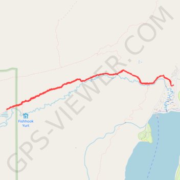
Fishhook Creek Trail in Sawtooth National Recreation Area
Fishhook Creek Trail offers a delightful hiking experience, showcasing the stunning beauty of the Sawtooth Mountains. As you traverse the trail, you’ll encounter lush meadows dotted with vibrant wildflowers, serene beaver ponds, and captivating views of towering peaks like Heyburn and Horstmann, making it a picturesque setting for both casual hikers and photography enthusiasts. #Hiking #Mountain #Forest #Nature
- Distance: 4.7 mi
- Elevation gain: 351 ft
- Maximum elevation: 6,850 ft
- Elevation loss: 354 ft
- Minimum elevation: 6,572 ft
- Moving time: 1 h 44 m
- Moving speed: 2.7 mph
- Maximum speed: 4.9 mph
- Total time: 2 h 17 m
- Global speed: 2.1 mph
Interactive trail map
Trail profile
- Distance: 4.7 mi
- Elevation gain: 351 ft
- Maximum elevation: 6,850 ft
- Elevation loss: 354 ft
- Minimum elevation: 6,572 ft
- Moving time: 1 h 44 m
- Moving speed: 2.7 mph
- Maximum speed: 4.9 mph
- Total time: 2 h 17 m
- Global speed: 2.1 mph
About this trail
Name: Fishhook Creek Trail in Sawtooth National Recreation Area trail, distance, elevation, map, profile, GPS track
Start: Fishhook Trail, Custer County, Idaho, United States (44.14744 -114.91959)
End: Fishhook Trail, Custer County, Idaho, United States (44.14754 -114.91914)
Coordinates: 44.14333 -114.95857 44.15004 -114.91911
Topography: Custer County topographic map, elevation, terrain
Other hiking, mountain biking, running and outdoor activity trails
Click on a trail to view its statistics, map and profile.
Bench Lakes Trail via Redfish Creek-Baron Creek Trail in Sawtooth Wilderness
United States > Idaho > Custer County
The Bench Lakes Trail offers a captivating hiking experience marked by stunning mountain vistas and crystal-clear alpine lakes. As you ascend, you’ll traverse lush forests and open meadows, all while keeping an eye out for local wildlife, such as deer and elk, and on the Redfish Lake below. A few challenging…
Distance: 8.4 mi • Elevation gain: 1,296 ft • Maximum elevation: 7,772 ft