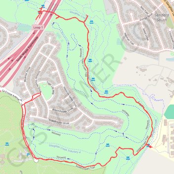
Violet Crown Trail from Slaughter Creek to Wildflower Center
- Distance: 4.7 mi
- Elevation gain: 128 ft
- Maximum elevation: 843 ft
- Elevation loss: 128 ft
- Minimum elevation: 778 ft
- Moving time: 1 h 41 m
- Moving speed: 2.8 mph
- Maximum speed: 3.7 mph
- Total time: 1 h 41 m
- Global speed: 2.8 mph
Interactive trail map
Trail profile
- Distance: 4.7 mi
- Elevation gain: 128 ft
- Maximum elevation: 843 ft
- Elevation loss: 128 ft
- Minimum elevation: 778 ft
- Moving time: 1 h 41 m
- Moving speed: 2.8 mph
- Maximum speed: 3.7 mph
- Total time: 1 h 41 m
- Global speed: 2.8 mph
About this trail
Name: Violet Crown Trail from Slaughter Creek to Wildflower Center trail, distance, elevation, map, profile, GPS track
Coordinates: 30.18508 -97.87172 30.19614 -97.86125
Topography: Austin topographic map, elevation, terrain
Other hiking, mountain biking, running and outdoor activity trails
Click on a trail to view its statistics, map and profile.
South Austin Single Track
United States > Texas > Travis County > Austin
Distance: 4.6 mi • Elevation gain: 52 ft • Maximum elevation: 889 ft