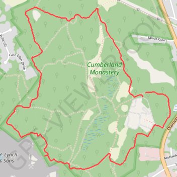
Cumberland Monastery Loop via Nine Men's Misery Trail, Orchard Trail, Monk's Quarry Trai, Whipple Trail, Overlook Viewpoint, Old Road Trail and Beauregard Loop
The Cumberland Monastery Loop offers a serene yet historically rich hiking experience. Winding through diverse trails, such as Nine Men's Misery, Orchard, and Beauregard, the route combines natural beauty with somber reminders of colonial history, highlighted by the 1676 Nine Men’s Misery memorial, one of the country’s oldest veterans' monuments. Alongside forested paths, visitors encounter tranquil overlooks, remnants of quarrying from early settlers, and scenic views over ponds and fields that reflect a harmonious blend of natural and historical Rhode Island charm. #Hiking #Loop #Forest #Lake #Nature
- Distance: 3.4 mi
- Elevation gain: 246 ft
- Maximum elevation: 331 ft
- Elevation loss: 246 ft
- Minimum elevation: 184 ft
- Moving time: 1 h 19 m
- Moving speed: 2.6 mph
- Maximum speed: 7.7 mph
- Total time: 1 h 20 m
- Global speed: 2.5 mph
Interactive trail map
Trail profile
- Distance: 3.4 mi
- Elevation gain: 246 ft
- Maximum elevation: 331 ft
- Elevation loss: 246 ft
- Minimum elevation: 184 ft
- Moving time: 1 h 19 m
- Moving speed: 2.6 mph
- Maximum speed: 7.7 mph
- Total time: 1 h 20 m
- Global speed: 2.5 mph
About this trail
Name: Cumberland Monastery Loop via Nine Men's Misery Trail, Orchard Trail, Monk's Quarry Trai, Whipple Trail, Overlook Viewpoint, Old Road Trail and Beauregard Loop trail, distance, elevation, map, profile, GPS track
Coordinates: 41.93029 -71.41823 41.94253 -71.40162
Topography: Providence County topographic map, elevation, terrain
Other hiking, mountain biking, running and outdoor activity trails
Click on a trail to view its statistics, map and profile.
Cambridge - Providence Express
United States > Massachusetts > Middlesex County > Cambridge
Alewife -> Providence
Distance: 63.2 mi • Elevation gain: 3,153 ft • Maximum elevation: 351 ft
Dedham-Providence-Dedham
United States > Massachusetts > Norfolk County > Dedham
Distance: 126.0 mi • Elevation gain: 5,942 ft • Maximum elevation: 548 ft