Thank you for supporting this site ❤️
Make a donation
Make a donation
Gear up for your next adventure:
As an Amazon Associate, this site earns from qualifying purchases at no extra cost to you.
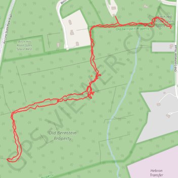
Old Bernstein Property
- Distance: 2.6 mi
- Elevation gain: 135 ft
- Maximum elevation: 446 ft
- Elevation loss: 135 ft
- Minimum elevation: 381 ft
- Moving time: 1 h 55 m
- Moving speed: 1.3 mph
- Maximum speed: 6.7 mph
- Total time: 2 h 45 m
- Global speed: 0.9 mph
Interactive trail map
Thank you for supporting this site ❤️
Make a donation
Make a donation
Gear up for your next adventure:
As an Amazon Associate, this site earns from qualifying purchases at no extra cost to you.
Trail profile
- Distance: 2.6 mi
- Elevation gain: 135 ft
- Maximum elevation: 446 ft
- Elevation loss: 135 ft
- Minimum elevation: 381 ft
- Moving time: 1 h 55 m
- Moving speed: 1.3 mph
- Maximum speed: 6.7 mph
- Total time: 2 h 45 m
- Global speed: 0.9 mph
Thank you for supporting this site ❤️
Make a donation
Make a donation
Gear up for your next adventure:
As an Amazon Associate, this site earns from qualifying purchases at no extra cost to you.
About this trail
Name: Old Bernstein Property trail, distance, elevation, map, profile, GPS track
Coordinates: 41.60432 -72.36826 41.61186 -72.35684
Topography: Capitol Planning Region topographic map, elevation, terrain
Thank you for supporting this site ❤️
Make a donation
Make a donation
Gear up for your next adventure:
As an Amazon Associate, this site earns from qualifying purchases at no extra cost to you.