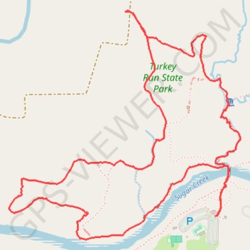
Ice Box, Falls Canyon, Bouder Canyon, Camel's Back, Punch Bowl, Rocky Hollow and Wedge Rock Loop from Suspension Bridge in Turkey Run State Park
This hiking route through Turkey Run State Park, encompassing Ice Box, Falls Canyon, Boulder Canyon, Camel's Back, Punch Bowl, Rocky Hollow, and Wedge Rock Loop, offers an exhilarating experience for outdoor enthusiasts. This journey traverses rugged terrain marked by steep cliffs and unique geological features, including picturesque canyons and the iconic Punch Bowl, known for its striking glacial formations. Hikers will also enjoy the challenge of crossing the park's suspension bridge, adding an element of adventure to a trail that showcases Indiana's natural beauty and biodiversity. #Hiking #Loop #River #Canyon #Forest #Nature
- Distance: 4.1 mi
- Elevation gain: 456 ft
- Maximum elevation: 705 ft
- Elevation loss: 456 ft
- Minimum elevation: 531 ft
- Moving time: 1 h 51 m
- Moving speed: 2.2 mph
- Maximum speed: 8.3 mph
- Total time: 2 h 2 m
- Global speed: 2.0 mph
Interactive trail map
Trail profile
- Distance: 4.1 mi
- Elevation gain: 456 ft
- Maximum elevation: 705 ft
- Elevation loss: 456 ft
- Minimum elevation: 531 ft
- Moving time: 1 h 51 m
- Moving speed: 2.2 mph
- Maximum speed: 8.3 mph
- Total time: 2 h 2 m
- Global speed: 2.0 mph
About this trail
Name: Ice Box, Falls Canyon, Bouder Canyon, Camel's Back, Punch Bowl, Rocky Hollow and Wedge Rock Loop from Suspension Bridge in Turkey Run State Park trail, distance, elevation, map, profile, GPS track
Start: Trail 1, Parke County, Indiana, 47859, United States (39.88698 -87.20037)
End: Trail 1, Parke County, Indiana, 47859, United States (39.88696 -87.20025)
Coordinates: 39.88576 -87.21441 39.89773 -87.19865
Topography: Parke County topographic map, elevation, terrain
Other hiking, mountain biking, running and outdoor activity trails
Click on a trail to view its statistics, map and profile.
Loop Trail 3 in Turkey Run State Park
United States > Indiana > Parke County
Loop Trail 3 in Turkey Run State Park offers a rugged hiking experience filled with breathtaking natural beauty. As you traverse the trail, you’ll encounter steep sandstone cliffs, picturesque canyons, and unique geological features like the Punch Bowl—a glacial pothole that showcases the area's…
Distance: 2.4 mi • Elevation gain: 318 ft • Maximum elevation: 692 ft