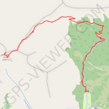
Grandeur Peak Trail in Uinta-Wasatch-Cache National Forest
The Grandeur Peak Trail offers hikers a scenic and relatively short but steep ascent through Utah's Wasatch Mountains. Starting at Church Fork, the trail follows a shaded creek before transitioning into a series of switchbacks, eventually leading to a ridge with panoramic views. Along the way, hikers can spot vibrant wildflowers, rocky outcroppings, and sweeping vistas of the Salt Lake Valley, Mount Olympus, and the surrounding canyons. #Hiking #Mountain #Forest #Nature #Overlook
- Distance: 5.8 mi
- Elevation gain: 2,336 ft
- Maximum elevation: 8,251 ft
- Elevation loss: 2,336 ft
- Minimum elevation: 5,915 ft
- Moving time: 1 h 59 m
- Moving speed: 2.9 mph
- Maximum speed: 8.2 mph
- Total time: 2 h 12 m
- Global speed: 2.6 mph
Interactive trail map
Trail profile
- Distance: 5.8 mi
- Elevation gain: 2,336 ft
- Maximum elevation: 8,251 ft
- Elevation loss: 2,336 ft
- Minimum elevation: 5,915 ft
- Moving time: 1 h 59 m
- Moving speed: 2.9 mph
- Maximum speed: 8.2 mph
- Total time: 2 h 12 m
- Global speed: 2.6 mph
About this trail
Name: Grandeur Peak Trail in Uinta-Wasatch-Cache National Forest trail, distance, elevation, map, profile, GPS track
Start: Church Fork, Grandeur Peak Trail, Salt Lake County, Utah, United States (40.70077 -111.74242)
End: Church Fork, Millcreek Inn Complex Road, Salt Lake County, Utah, United States (40.70075 -111.74235)
Coordinates: 40.70075 -111.76012 40.71287 -111.73893
Topography: Salt Lake County topographic map, elevation, terrain
Other hiking, mountain biking, running and outdoor activity trails
Click on a trail to view its statistics, map and profile.