Make a donation
Gear up for your next adventure:
As an Amazon Associate, this site earns from qualifying purchases at no extra cost to you.
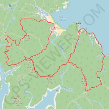
風琴坑 流白水 螺地墩北坑右
Hong Kong Hike
- Distance: 7.8 mi
- Elevation gain: 2,513 ft
- Maximum elevation: 971 ft
- Elevation loss: 2,523 ft
- Minimum elevation: 0 ft
- Moving time: 3 h 53 m
- Moving speed: 2.0 mph
- Maximum speed: 24.2 mph
- Total time: 6 h 59 m
- Global speed: 1.1 mph
Interactive trail map
Make a donation
Gear up for your next adventure:
As an Amazon Associate, this site earns from qualifying purchases at no extra cost to you.
Trail profile
- Distance: 7.8 mi
- Elevation gain: 2,513 ft
- Maximum elevation: 971 ft
- Elevation loss: 2,523 ft
- Minimum elevation: 0 ft
- Moving time: 3 h 53 m
- Moving speed: 2.0 mph
- Maximum speed: 24.2 mph
- Total time: 6 h 59 m
- Global speed: 1.1 mph
Make a donation
Gear up for your next adventure:
As an Amazon Associate, this site earns from qualifying purchases at no extra cost to you.
About this trail
Name: 風琴坑 流白水 螺地墩北坑右 trail, distance, elevation, map, profile, GPS track
Coordinates: 22.38413 114.35990 22.39924 114.38231
Make a donation
Gear up for your next adventure:
As an Amazon Associate, this site earns from qualifying purchases at no extra cost to you.
Other hiking, mountain biking, running and outdoor activity trails
Click on a trail to view its statistics, map and profile.
田尾下源 橫頭墩北坑 田鹿石澗左 蛇地 秋楓
China > Hong Kong > Sai Kung District > Tsak Yue Wu
Distance: 13.1 mi • Elevation gain: 2,661 ft • Maximum elevation: 1,102 ft
麦理浩径
China > Hong Kong > Sai Kung District > Tsak Yue Wu
北潭涌至屯门
Distance: 61.3 mi • Elevation gain: 16,886 ft • Maximum elevation: 3,031 ft