Hartlepool Bicycle
- Distance: 14.6 mi
- Elevation gain: 217 ft
- Maximum elevation: 75 ft
- Elevation loss: 207 ft
- Minimum elevation: -3 ft
- Moving time: 1 h 55 m
- Moving speed: 7.6 mph
- Maximum speed: 14.0 mph
- Total time: 1 h 58 m
- Global speed: 7.4 mph
Interactive trail map
Trail profile
- Distance: 14.6 mi
- Elevation gain: 217 ft
- Maximum elevation: 75 ft
- Elevation loss: 207 ft
- Minimum elevation: -3 ft
- Moving time: 1 h 55 m
- Moving speed: 7.6 mph
- Maximum speed: 14.0 mph
- Total time: 1 h 58 m
- Global speed: 7.4 mph
About this trail
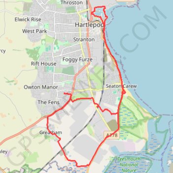
Name: Hartlepool Bicycle trail, distance, elevation, map, profile, GPS track
Coordinates: 54.62692 -1.23998 54.69318 -1.18405
Other hiking, mountain biking, running and outdoor activity trails
Click on a trail to view its statistics, map and profile.
Hartlepool Loop
United Kingdom > England > Hartlepool
Distance: 35.0 mi • Elevation gain: 1,099 ft • Maximum elevation: 449 ft