Thank you for supporting this site ❤️
Make a donation
Make a donation
Gear up for your next adventure:
As an Amazon Associate, this site earns from qualifying purchases at no extra cost to you.
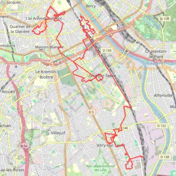
Le Street Art dans le Sud Parisien
- Distance: 17.6 mi
- Elevation gain: 531 ft
- Maximum elevation: 236 ft
- Elevation loss: 630 ft
- Minimum elevation: 105 ft
Interactive trail map
Thank you for supporting this site ❤️
Make a donation
Make a donation
Gear up for your next adventure:
As an Amazon Associate, this site earns from qualifying purchases at no extra cost to you.
Trail profile
- Distance: 17.6 mi
- Elevation gain: 531 ft
- Maximum elevation: 236 ft
- Elevation loss: 630 ft
- Minimum elevation: 105 ft
Thank you for supporting this site ❤️
Make a donation
Make a donation
Gear up for your next adventure:
As an Amazon Associate, this site earns from qualifying purchases at no extra cost to you.
About this trail
Name: Le Street Art dans le Sud Parisien trail, distance, elevation, map, profile, GPS track
Coordinates: 48.77897 2.34947 48.83647 2.40925
Thank you for supporting this site ❤️
Make a donation
Make a donation
Gear up for your next adventure:
As an Amazon Associate, this site earns from qualifying purchases at no extra cost to you.