Make a donation
Gear up for your next adventure:
As an Amazon Associate, this site earns from qualifying purchases at no extra cost to you.
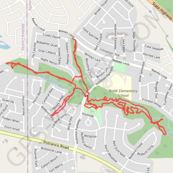
Red Bird Ranch Trails
Redbird, Mountain bike, Trail, Hiking, Walking, Creek, Biking, Wandering
- Distance: 5.1 mi
- Elevation gain: 128 ft
- Maximum elevation: 981 ft
- Elevation loss: 128 ft
- Minimum elevation: 922 ft
Interactive trail map
Make a donation
Gear up for your next adventure:
As an Amazon Associate, this site earns from qualifying purchases at no extra cost to you.
Trail profile
- Distance: 5.1 mi
- Elevation gain: 128 ft
- Maximum elevation: 981 ft
- Elevation loss: 128 ft
- Minimum elevation: 922 ft
Make a donation
Gear up for your next adventure:
As an Amazon Associate, this site earns from qualifying purchases at no extra cost to you.
About this trail
Name: Red Bird Ranch Trails trail, distance, elevation, map, profile, GPS track
Start: Poolside, Redbird Ranch, Bexar County, Texas, United States (29.43241 -98.79737)
End: Poolside, Redbird Ranch, Bexar County, Texas, United States (29.43250 -98.79729)
Coordinates: 29.42990 -98.80762 29.43945 -98.78944
Topography: Bexar County topographic map, elevation, terrain
Make a donation
Gear up for your next adventure:
As an Amazon Associate, this site earns from qualifying purchases at no extra cost to you.