2015-07-19 Mt Fallere
Mt Fallere vanuit Vetan
6,5h
1400m up and down
19km
- Distance: 11.3 mi
- Elevation gain: 4,780 ft
- Maximum elevation: 9,938 ft
- Elevation loss: 4,531 ft
- Minimum elevation: 5,607 ft
- Moving time: 5 h 39 m
- Moving speed: 2.0 mph
- Maximum speed: 4.8 mph
- Total time: 7 h 1 m
- Global speed: 1.6 mph
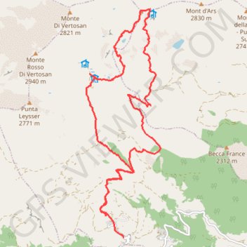
Interactive trail map
Trail profile
- Distance: 11.3 mi
- Elevation gain: 4,780 ft
- Maximum elevation: 9,938 ft
- Elevation loss: 4,531 ft
- Minimum elevation: 5,607 ft
- Moving time: 5 h 39 m
- Moving speed: 2.0 mph
- Maximum speed: 4.8 mph
- Total time: 7 h 1 m
- Global speed: 1.6 mph
About this trail
Name: 2015-07-19 Mt Fallere trail, distance, elevation, map, profile, GPS track
Start: Vetan Villette, Saint-Pierre, Aosta Valley, 11018, Italy (45.73036 7.18961)
Coordinates: 45.73036 7.17901 45.77576 7.20025
Other hiking, mountain biking, running and outdoor activity trails
Click on a trail to view its statistics, map and profile.
PT23DS2 Lörrach → Cadaqués
Germany > Baden-Württemberg > Landkreis Lörrach > Lörrach (Kernstadt)
Distance: 652.9 mi • Elevation gain: 43,077 ft • Maximum elevation: 4,938 ft
2015-07-19 Mt Fallere
Italy > Aosta Valley > Saint-Pierre > Vetan Villette
Distance: 11.3 mi • Elevation gain: 4,770 ft • Maximum elevation: 9,934 ft