Thank you for supporting this site ❤️
Make a donation
Make a donation
Gear up for your next adventure:
As an Amazon Associate, this site earns from qualifying purchases at no extra cost to you.
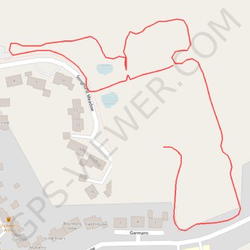
Path around songhurst meadow park
- Distance: 0.5 mi
- Elevation gain: 13 ft
- Maximum elevation: 79 ft
- Elevation loss: 16 ft
- Minimum elevation: 62 ft
- Moving time: 11 m 22 s
- Moving speed: 2.7 mph
- Maximum speed: 3.6 mph
- Total time: 12 m 8 s
- Global speed: 2.5 mph
Interactive trail map
Thank you for supporting this site ❤️
Make a donation
Make a donation
Gear up for your next adventure:
As an Amazon Associate, this site earns from qualifying purchases at no extra cost to you.
Trail profile
- Distance: 0.5 mi
- Elevation gain: 13 ft
- Maximum elevation: 79 ft
- Elevation loss: 16 ft
- Minimum elevation: 62 ft
- Moving time: 11 m 22 s
- Moving speed: 2.7 mph
- Maximum speed: 3.6 mph
- Total time: 12 m 8 s
- Global speed: 2.5 mph
Thank you for supporting this site ❤️
Make a donation
Make a donation
Gear up for your next adventure:
As an Amazon Associate, this site earns from qualifying purchases at no extra cost to you.
About this trail
Name: Path around songhurst meadow park trail, distance, elevation, map, profile, GPS track
Coordinates: 51.02477 -0.50402 51.02659 -0.50086
Thank you for supporting this site ❤️
Make a donation
Make a donation
Gear up for your next adventure:
As an Amazon Associate, this site earns from qualifying purchases at no extra cost to you.