Thank you for supporting this site ❤️
Make a donation
Make a donation
Gear up for your next adventure:
As an Amazon Associate, this site earns from qualifying purchases at no extra cost to you.
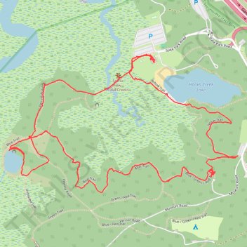
Cheesequake State Park
- Distance: 3.2 mi
- Elevation gain: 157 ft
- Maximum elevation: 69 ft
- Elevation loss: 151 ft
- Minimum elevation: 3 ft
- Moving time: 1 h 28 m
- Moving speed: 2.2 mph
- Maximum speed: 4.2 mph
- Total time: 2 h 27 m
- Global speed: 1.3 mph
Interactive trail map
Thank you for supporting this site ❤️
Make a donation
Make a donation
Gear up for your next adventure:
As an Amazon Associate, this site earns from qualifying purchases at no extra cost to you.
Trail profile
- Distance: 3.2 mi
- Elevation gain: 157 ft
- Maximum elevation: 69 ft
- Elevation loss: 151 ft
- Minimum elevation: 3 ft
- Moving time: 1 h 28 m
- Moving speed: 2.2 mph
- Maximum speed: 4.2 mph
- Total time: 2 h 27 m
- Global speed: 1.3 mph
Thank you for supporting this site ❤️
Make a donation
Make a donation
Gear up for your next adventure:
As an Amazon Associate, this site earns from qualifying purchases at no extra cost to you.
About this trail
Name: Cheesequake State Park trail, distance, elevation, map, profile, GPS track
Coordinates: 40.43458 -74.27858 40.44057 -74.26554
Topography: Middlesex County topographic map, elevation, terrain
Thank you for supporting this site ❤️
Make a donation
Make a donation
Gear up for your next adventure:
As an Amazon Associate, this site earns from qualifying purchases at no extra cost to you.