Make a donation
Gear up for your next adventure:
As an Amazon Associate, this site earns from qualifying purchases at no extra cost to you.
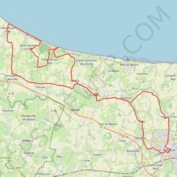
Bayeux Boucle ouest courte
- Distance: 35.3 mi
- Elevation gain: 1,444 ft
- Maximum elevation: 249 ft
- Elevation loss: 1,437 ft
- Minimum elevation: 0 ft
Interactive trail map
Make a donation
Gear up for your next adventure:
As an Amazon Associate, this site earns from qualifying purchases at no extra cost to you.
Trail profile
- Distance: 35.3 mi
- Elevation gain: 1,444 ft
- Maximum elevation: 249 ft
- Elevation loss: 1,437 ft
- Minimum elevation: 0 ft
Make a donation
Gear up for your next adventure:
As an Amazon Associate, this site earns from qualifying purchases at no extra cost to you.
About this trail
Name: Bayeux Boucle ouest courte trail, distance, elevation, map, profile, GPS track
Coordinates: 49.27359 -0.90623 49.37905 -0.70111
Make a donation
Gear up for your next adventure:
As an Amazon Associate, this site earns from qualifying purchases at no extra cost to you.
Other hiking, mountain biking, running and outdoor activity trails
Click on a trail to view its statistics, map and profile.
Arromanches PortenBessin
France > Normandy > Calvados > Arromanches-les-Bains
Distance: 8.6 mi • Elevation gain: 646 ft • Maximum elevation: 243 ft
Bayeux boucle ouest longue
France > Normandy > Calvados > Bayeux
Distance: 46.3 mi • Elevation gain: 1,795 ft • Maximum elevation: 249 ft
PortEnBessin Loop
France > Normandy > Calvados > Port-en-Bessin-Huppain
Distance: 15.3 mi • Elevation gain: 915 ft • Maximum elevation: 256 ft
PortEnBessin-Bayeux
France > Normandy > Calvados > Port-en-Bessin-Huppain
Distance: 10.9 mi • Elevation gain: 512 ft • Maximum elevation: 220 ft
Make a donation
Gear up for your next adventure:
As an Amazon Associate, this site earns from qualifying purchases at no extra cost to you.
Bayeux-Caen Long
France > Normandy > Calvados > Bayeux
Distance: 39.9 mi • Elevation gain: 1,503 ft • Maximum elevation: 253 ft
Bayeux East short loop
France > Normandy > Calvados > Bayeux
Distance: 17.5 mi • Elevation gain: 732 ft • Maximum elevation: 243 ft