Make a donation
Gear up for your next adventure:
As an Amazon Associate, this site earns from qualifying purchases at no extra cost to you.
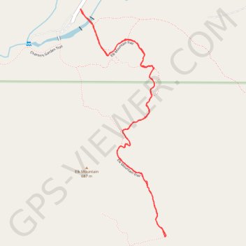
Elk Mountain Trail in Charons Garden Wilderness Area
The Elk Mountain Trail offers a rewarding hiking experience with its gradual ascent leading to stunning panoramic views of the Wichita Mountains, Mount Lincoln and surrounding landscapes. Along the route, hikers can encounter unique geological features, including granite slabs and boulder formations, as well as diverse wildlife like the colorful Boomer Lizard. The trail's combination of well-defined paths and challenging scrambles near the summit provides an engaging adventure for both novice and seasoned hikers. #Hiking #Mountain #Forest #Nature
- Distance: 2.3 mi
- Elevation gain: 584 ft
- Maximum elevation: 2,224 ft
- Elevation loss: 584 ft
- Minimum elevation: 1,654 ft
- Moving time: 1 h 38 m
- Moving speed: 1.4 mph
- Maximum speed: 3.1 mph
- Total time: 2 h 5 m
- Global speed: 1.1 mph
Interactive trail map
Make a donation
Gear up for your next adventure:
As an Amazon Associate, this site earns from qualifying purchases at no extra cost to you.
Trail profile
- Distance: 2.3 mi
- Elevation gain: 584 ft
- Maximum elevation: 2,224 ft
- Elevation loss: 584 ft
- Minimum elevation: 1,654 ft
- Moving time: 1 h 38 m
- Moving speed: 1.4 mph
- Maximum speed: 3.1 mph
- Total time: 2 h 5 m
- Global speed: 1.1 mph
Make a donation
Gear up for your next adventure:
As an Amazon Associate, this site earns from qualifying purchases at no extra cost to you.
About this trail
Name: Elk Mountain Trail in Charons Garden Wilderness Area trail, distance, elevation, map, profile, GPS track
Start: Elk Mountain Trail, Comanche County, Oklahoma, United States (34.73207 -98.72374)
End: Elk Mountain Trail, Comanche County, Oklahoma, United States (34.73207 -98.72375)
Coordinates: 34.72159 -98.72375 34.73207 -98.71895
Topography: Comanche County topographic map, elevation, terrain
Make a donation
Gear up for your next adventure:
As an Amazon Associate, this site earns from qualifying purchases at no extra cost to you.
Other hiking, mountain biking, running and outdoor activity trails
Click on a trail to view its statistics, map and profile.
Charon's Garden Trail and Elk Mountain Trail hiking in Wichita Mountains Wildlife Refuge
United States > Oklahoma > Comanche County
Distance: 8.6 mi • Elevation gain: 1,155 ft • Maximum elevation: 2,224 ft