Thank you for supporting this site ❤️
Make a donation
Make a donation
Gear up for your next adventure:
As an Amazon Associate, this site earns from qualifying purchases at no extra cost to you.
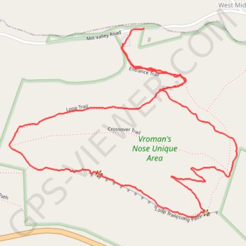
Vroman's Nose Loop Trail
- Distance: 2.0 mi
- Elevation gain: 472 ft
- Maximum elevation: 1,158 ft
- Elevation loss: 482 ft
- Minimum elevation: 758 ft
- Moving time: 52 m 24 s
- Moving speed: 2.2 mph
- Maximum speed: 10.7 mph
- Total time: 59 m 59 s
- Global speed: 2.0 mph
Interactive trail map
Thank you for supporting this site ❤️
Make a donation
Make a donation
Gear up for your next adventure:
As an Amazon Associate, this site earns from qualifying purchases at no extra cost to you.
Trail profile
- Distance: 2.0 mi
- Elevation gain: 472 ft
- Maximum elevation: 1,158 ft
- Elevation loss: 482 ft
- Minimum elevation: 758 ft
- Moving time: 52 m 24 s
- Moving speed: 2.2 mph
- Maximum speed: 10.7 mph
- Total time: 59 m 59 s
- Global speed: 2.0 mph
Thank you for supporting this site ❤️
Make a donation
Make a donation
Gear up for your next adventure:
As an Amazon Associate, this site earns from qualifying purchases at no extra cost to you.
About this trail
Name: Vroman's Nose Loop Trail trail, distance, elevation, map, profile, GPS track
Start: Entrance Trail, Town of Fulton, Schoharie County, New York, United States (42.59445 -74.35813)
Coordinates: 42.58936 -74.36268 42.59492 -74.35355
Topography: Schoharie County topographic map, elevation, terrain
Thank you for supporting this site ❤️
Make a donation
Make a donation
Gear up for your next adventure:
As an Amazon Associate, this site earns from qualifying purchases at no extra cost to you.