
Dripping Cave
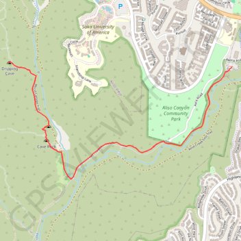
Starting from the Aliso Viejo side of Aliso and Wood Canyons Wilderness Park, the route enters the open Aliso Creek corridor and follows Aliso Creek Trail through a broad canyon floor of coastal sage scrub, riparian vegetation, and rounded hills.
It then bends toward the junction with Wood Canyon Trail, leaving the wider Aliso Creek valley for the quieter Wood Canyon corridor, where Wood Creek, sycamores, oaks, and sandstone slopes give the hike a more enclosed canyon character.
Near the end, a signed spur on Dripping Cave Trail leads to Dripping Cave itself, the park’s largest sandstone rock shelter, historically known as Robbers Cave and associated with Native American shelter use and later outlaw folklore.
#Hiking #Cave #Canyon #River #Nature #Mountain #Forest #Park #Creek #Wilderness #Sandstone
- Distance: 2.5 mi
- Elevation gain: 240 ft
- Maximum elevation: 246 ft
- Elevation loss: 148 ft
- Minimum elevation: 89 ft
Interactive trail map
Trail profile
- Distance: 2.5 mi
- Elevation gain: 240 ft
- Maximum elevation: 246 ft
- Elevation loss: 148 ft
- Minimum elevation: 89 ft
About this trail
Name: Dripping Cave trail, distance, elevation, map, profile, GPS track
Coordinates: 33.54114 -117.74433 33.55174 -117.72022
Topography: Orange County topographic map, elevation, terrain