
The Ruined Castle - Blue Mountains National Park
- Distance: 2.5 mi
- Elevation gain: 505 ft
- Maximum elevation: 3,107 ft
- Elevation loss: 1,079 ft
- Minimum elevation: 2,356 ft
Interactive trail map
Trail profile
- Distance: 2.5 mi
- Elevation gain: 505 ft
- Maximum elevation: 3,107 ft
- Elevation loss: 1,079 ft
- Minimum elevation: 2,356 ft
About this trail
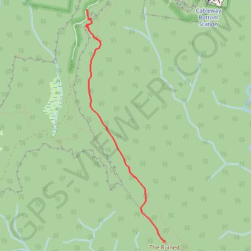
Name: The Ruined Castle - Blue Mountains National Park trail, distance, elevation, map, profile, GPS track
Coordinates: -33.76346 150.28236 -33.73440 150.29419
Other hiking, mountain biking, running and outdoor activity trails
Click on a trail to view its statistics, map and profile.
Hike from Bushwalkers Campsite at New Yards to Katoomba via Scotts Main Ridge, White Dog Ridge and Narrow Neck in Blue Mountains National Park
Distance: 21.4 mi • Elevation gain: 5,820 ft • Maximum elevation: 3,491 ft

Mount Solitary - Kedumba Valley
Australia > New South Wales > Sydney > Katoomba
Blue Mountains National Park. #Hiking #Loop #BlueMountains
Distance: 21.7 mi • Elevation gain: 8,176 ft • Maximum elevation: 3,225 ft
Splendour Rock to Katoomba
Distance: 14.0 mi • Elevation gain: 3,064 ft • Maximum elevation: 3,491 ft
Six Foot Track
Australia > New South Wales > Sydney > Katoomba
Hike / Bike. Kanagra-Boyd National Park. #Hiking #Bike #KanagraBoyd
Distance: 27.9 mi • Elevation gain: 5,194 ft • Maximum elevation: 3,957 ft