Ponca Wilderness and Buffalo National River Loop
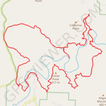
Interactive trail map
Trail profile
- Distance: 18.8 mi
- Elevation gain: 4,354 ft
- Maximum elevation: 2,165 ft
- Elevation loss: 4,354 ft
- Minimum elevation: 922 ft
About this trail
Name: Ponca Wilderness and Buffalo National River Loop trail, distance, elevation, map, profile, GPS track
Start: Buffalo River Trail, Pruitt, Newton County, Arkansas, 72670, United States (36.03945 -93.34606)
End: Buffalo River Trail, Pruitt, Newton County, Arkansas, 72670, United States (36.03945 -93.34606)
Coordinates: 36.03213 -93.36083 36.07165 -93.29953
Topography: Newton County topographic map, elevation, terrain
Other hiking, mountain biking, running and outdoor activity trails
Click on a trail to view its statistics, map and profile.
Big Bluff Overlook via Centerpoint Trail and Goat Trail in Buffalo National River
United States > Arkansas > Newton County > Ponca
The hike to Big Bluff Overlook offers a stunning blend of natural beauty and challenging terrain. As you make your way along the Centerpoint Trail and the narrow Goat Trail, you’re treated to breathtaking panoramic views of the Buffalo River winding through the Ozark Mountains, with ample opportunities to…
Distance: 6.1 mi • Elevation gain: 1,188 ft • Maximum elevation: 2,185 ft