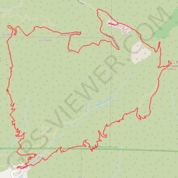
Mount Lukens Loop from Deukmejian Wilderness Park
Starting at Mount Lukens Trailhead in Deukmejian Wilderness Park, the route first leaves the Stone Barn area, crosses Dunsmore Creek on the lower park connector, and joins Crescenta View Trail before climbing through chaparral and sage scrub above Dunsmore Canyon toward The Redoubt.
The ascent continues over open, sun-exposed slopes toward Silver Saddle and Mount Lukens Road, where the route enters the higher San Gabriel Mountains setting and reaches the antenna-marked summit of Mount Lukens, with broad views over Crescenta Valley, the Los Angeles Basin, and the surrounding Angeles National Forest.
The return leaves the summit by Haines Canyon Road, then descends on the Rim of the Valley Trail across canyon rims and recovering woodland before closing near Cook Canyon and Le Mesnager Loop Trail, where shaded drainage, lower-park vegetation, and the Stone Barn area bring the circuit back to Mount Lukens Trailhead.
#Hiking #Loop #Mountain #Nature #Forest #Angeles #Summit #Canyon #Views #Wilderness #Ridge
- Distance: 9.9 mi
- Elevation gain: 3,494 ft
- Maximum elevation: 5,043 ft
- Elevation loss: 3,491 ft
- Minimum elevation: 2,346 ft
- Moving time: 1 h 34 m
- Moving speed: 6.3 mph
- Maximum speed: 8.1 mph
- Total time: 1 h 34 m
- Global speed: 6.3 mph
Interactive trail map
Trail profile
- Distance: 9.9 mi
- Elevation gain: 3,494 ft
- Maximum elevation: 5,043 ft
- Elevation loss: 3,491 ft
- Minimum elevation: 2,346 ft
- Moving time: 1 h 34 m
- Moving speed: 6.3 mph
- Maximum speed: 8.1 mph
- Total time: 1 h 34 m
- Global speed: 6.3 mph
About this trail
Name: Mount Lukens Loop from Deukmejian Wilderness Park trail, distance, elevation, map, profile, GPS track
Coordinates: 34.24964 -118.25543 34.27084 -118.22890
Topography: Glendale topographic map, elevation, terrain
Other hiking, mountain biking, running and outdoor activity trails
Click on a trail to view its statistics, map and profile.
Mount Lukens
United States > California > Los Angeles County
Final upper stone canyon trail upper switchbacks restoration
Distance: 9.0 mi • Elevation gain: 1,706 ft • Maximum elevation: 5,043 ft