Make a donation
Gear up for your next adventure:
As an Amazon Associate, this site earns from qualifying purchases at no extra cost to you.
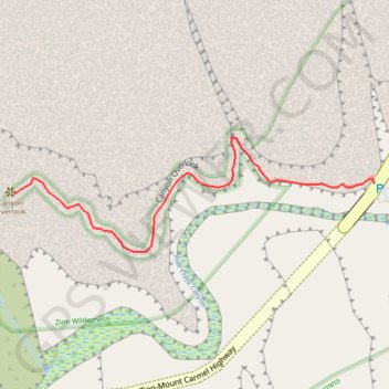
Zion Canyon Overlook
Starting near the Zion–Mount Carmel Tunnel, the Canyon Overlook Trail climbs sandstone steps and follows rocky ledges above Pine Creek’s shadowed slot canyon.
The route then winds through pale slickrock, canyon walls, desert shrubs, and sheltered alcoves, with chances to spot bighorn sheep along the way.
It finishes at a fenced cliff-edge viewpoint over lower Zion Canyon, with broad views toward the Towers of the Virgin and the park’s red-and-cream sandstone landscape.
#Hiking #Canyon #Mountain #Nature #Zion #Cliff #Rock
- Distance: 0.5 mi
- Elevation gain: 220 ft
- Maximum elevation: 5,312 ft
- Elevation loss: 374 ft
- Minimum elevation: 5,010 ft
Interactive trail map
Make a donation
Gear up for your next adventure:
As an Amazon Associate, this site earns from qualifying purchases at no extra cost to you.
Trail profile
- Distance: 0.5 mi
- Elevation gain: 220 ft
- Maximum elevation: 5,312 ft
- Elevation loss: 374 ft
- Minimum elevation: 5,010 ft
Make a donation
Gear up for your next adventure:
As an Amazon Associate, this site earns from qualifying purchases at no extra cost to you.
About this trail
Name: Zion Canyon Overlook trail, distance, elevation, map, profile, GPS track
Start: Zion-Mount Carmel Highway, Washington County, Utah, United States (37.21344 -112.94062)
End: Canyon Overlook Trail, Washington County, Utah, United States (37.21331 -112.94595)
Coordinates: 37.21264 -112.94595 37.21399 -112.94062
Topography: Washington County topographic map, elevation, terrain
Make a donation
Gear up for your next adventure:
As an Amazon Associate, this site earns from qualifying purchases at no extra cost to you.
Other hiking, mountain biking, running and outdoor activity trails
Click on a trail to view its statistics, map and profile.
Pullout via Canyon Overlook
United States > Utah > Washington County
Distance: 1.9 mi • Elevation gain: 1,214 ft • Maximum elevation: 5,318 ft