Make a donation
Gear up for your next adventure:
As an Amazon Associate, this site earns from qualifying purchases at no extra cost to you.
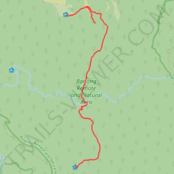
Ropers Hut to Cleve Cole Hut via Howman Falls in Bogong Natural Area
- Distance: 7.8 mi
- Elevation gain: 2,913 ft
- Maximum elevation: 5,807 ft
- Elevation loss: 2,687 ft
- Minimum elevation: 3,353 ft
- Moving time: 4 h 41 m
- Moving speed: 1.7 mph
- Maximum speed: 3.6 mph
- Total time: 7 h 15 m
- Global speed: 1.1 mph
Interactive trail map
Make a donation
Gear up for your next adventure:
As an Amazon Associate, this site earns from qualifying purchases at no extra cost to you.
Trail profile
- Distance: 7.8 mi
- Elevation gain: 2,913 ft
- Maximum elevation: 5,807 ft
- Elevation loss: 2,687 ft
- Minimum elevation: 3,353 ft
- Moving time: 4 h 41 m
- Moving speed: 1.7 mph
- Maximum speed: 3.6 mph
- Total time: 7 h 15 m
- Global speed: 1.1 mph
Make a donation
Gear up for your next adventure:
As an Amazon Associate, this site earns from qualifying purchases at no extra cost to you.
About this trail
Name: Ropers Hut to Cleve Cole Hut via Howman Falls in Bogong Natural Area trail, distance, elevation, map, profile, GPS track
End: Long Spur, Nelse, Shire of East Gippsland, Victoria, Australia (-36.75656 147.32769)
Coordinates: -36.81042 147.32769 -36.75315 147.34603
Make a donation
Gear up for your next adventure:
As an Amazon Associate, this site earns from qualifying purchases at no extra cost to you.
Other hiking, mountain biking, running and outdoor activity trails
Click on a trail to view its statistics, map and profile.
Mount Bogong from Cleve Cole Hut to Ropers Hut in Australian Alps
Distance: 14.4 mi • Elevation gain: 3,383 ft • Maximum elevation: 6,509 ft
Rocky Valley Storage to Ropers Hut via Mount Nelse in Australian Alps
Distance: 7.0 mi • Elevation gain: 965 ft • Maximum elevation: 6,165 ft