ACFA -Noct 2022-La Trans-côtes
Noct'BlanzaTraill
26 novembre 2022
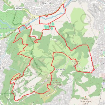
Parcours de la Trans-Côtes
- Distance: 11.2 mi
- Elevation gain: 2,021 ft
- Maximum elevation: 2,001 ft
- Elevation loss: 2,018 ft
- Minimum elevation: 1,194 ft
- Moving time: 2 h 15 m
- Moving speed: 5.0 mph
- Maximum speed: 5.5 mph
- Total time: 2 h 15 m
- Global speed: 5.0 mph
Interactive trail map
Trail profile
- Distance: 11.2 mi
- Elevation gain: 2,021 ft
- Maximum elevation: 2,001 ft
- Elevation loss: 2,018 ft
- Minimum elevation: 1,194 ft
- Moving time: 2 h 15 m
- Moving speed: 5.0 mph
- Maximum speed: 5.5 mph
- Total time: 2 h 15 m
- Global speed: 5.0 mph
About this trail
Name: ACFA -Noct 2022-La Trans-côtes trail, distance, elevation, map, profile, GPS track
Coordinates: 45.79903 3.06165 45.82807 3.09785
Other hiking, mountain biking, running and outdoor activity trails
Click on a trail to view its statistics, map and profile.
PT23DS2 Lörrach → Cadaqués
Germany > Baden-Württemberg > Landkreis Lörrach > Lörrach (Kernstadt)
Distance: 652.9 mi • Elevation gain: 43,077 ft • Maximum elevation: 4,938 ft
Chemin de Saint-Jacques-de-Compostelle
Switzerland > Geneva > Geneva
Distance: 694.6 mi • Elevation gain: 82,881 ft • Maximum elevation: 4,692 ft
GR 654 - Le chemin vers Saint-Jacques-de-Compostelle via Vézelay
France > Nouvelle-Aquitaine > Dordogne > Bergerac
Distance: 503.8 mi • Elevation gain: 31,598 ft • Maximum elevation: 2,198 ft