Thank you for supporting this site ❤️
Make a donation
Make a donation
Gear up for your next adventure:
As an Amazon Associate, this site earns from qualifying purchases at no extra cost to you.
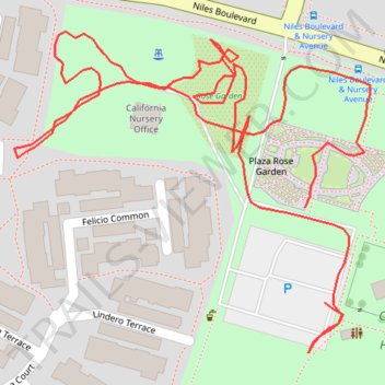
Rose Garden path tracks
- Distance: 0.7 mi
- Elevation gain: 10 ft
- Maximum elevation: 72 ft
- Elevation loss: 10 ft
- Minimum elevation: 62 ft
- Moving time: 18 m 34 s
- Moving speed: 2.2 mph
- Maximum speed: 14.1 mph
- Total time: 20 m 26 s
- Global speed: 2.0 mph
Interactive trail map
Thank you for supporting this site ❤️
Make a donation
Make a donation
Gear up for your next adventure:
As an Amazon Associate, this site earns from qualifying purchases at no extra cost to you.
Trail profile
- Distance: 0.7 mi
- Elevation gain: 10 ft
- Maximum elevation: 72 ft
- Elevation loss: 10 ft
- Minimum elevation: 62 ft
- Moving time: 18 m 34 s
- Moving speed: 2.2 mph
- Maximum speed: 14.1 mph
- Total time: 20 m 26 s
- Global speed: 2.0 mph
Thank you for supporting this site ❤️
Make a donation
Make a donation
Gear up for your next adventure:
As an Amazon Associate, this site earns from qualifying purchases at no extra cost to you.
About this trail
Name: Rose Garden path tracks trail, distance, elevation, map, profile, GPS track
Coordinates: 37.57802 -121.99268 37.57970 -121.99033
Topography: Fremont topographic map, elevation, terrain
Thank you for supporting this site ❤️
Make a donation
Make a donation
Gear up for your next adventure:
As an Amazon Associate, this site earns from qualifying purchases at no extra cost to you.