Ruj
- Distance: 11.2 mi
- Elevation gain: 3,675 ft
- Maximum elevation: 5,587 ft
- Elevation loss: 3,675 ft
- Minimum elevation: 2,510 ft
- Moving time: 6 h 45 m
- Moving speed: 1.7 mph
- Maximum speed: 3.9 mph
- Total time: 7 h 53 m
- Global speed: 1.4 mph
Interactive trail map
Trail profile
- Distance: 11.2 mi
- Elevation gain: 3,675 ft
- Maximum elevation: 5,587 ft
- Elevation loss: 3,675 ft
- Minimum elevation: 2,510 ft
- Moving time: 6 h 45 m
- Moving speed: 1.7 mph
- Maximum speed: 3.9 mph
- Total time: 7 h 53 m
- Global speed: 1.4 mph
About this trail
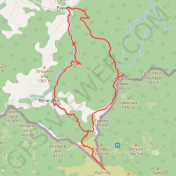
Name: Ruj trail, distance, elevation, map, profile, GPS track
Coordinates: 42.86224 22.55400 42.91347 22.58412
Other hiking, mountain biking, running and outdoor activity trails
Click on a trail to view its statistics, map and profile.
Rakita - Rakitski kamik - Ruj
Serbia > Central Serbia > Pirot Administrative District > Babusnica Municipality > Rakita
Distance: 13.5 mi • Elevation gain: 3,809 ft • Maximum elevation: 5,591 ft
Ruj planina: Rakita, vrh Rakitski kamik, vrh Ruj, Vuči Del, ...
Serbia > Central Serbia > Pirot Administrative District > Babusnica Municipality > Rakita
Distance: 12.3 mi • Elevation gain: 3,891 ft • Maximum elevation: 5,584 ft
USPON NA RUJ
Serbia > Central Serbia > Pirot Administrative District > Babusnica Municipality > Rakita
Distance: 11.2 mi • Elevation gain: 3,665 ft • Maximum elevation: 5,584 ft