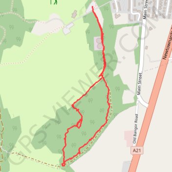
Conlig Wood main path
County Down Hiking
- Distance: 1.7 mi
- Elevation gain: 217 ft
- Maximum elevation: 446 ft
- Elevation loss: 217 ft
- Minimum elevation: 282 ft
- Moving time: 55 m 48 s
- Moving speed: 1.8 mph
- Maximum speed: 3.8 mph
- Total time: 1 h 23 m
- Global speed: 1.2 mph
Interactive trail map
Trail profile
- Distance: 1.7 mi
- Elevation gain: 217 ft
- Maximum elevation: 446 ft
- Elevation loss: 217 ft
- Minimum elevation: 282 ft
- Moving time: 55 m 48 s
- Moving speed: 1.8 mph
- Maximum speed: 3.8 mph
- Total time: 1 h 23 m
- Global speed: 1.2 mph
About this trail
Name: Conlig Wood main path trail, distance, elevation, map, profile, GPS track
Start: Main Street, Conlig, County Down, Northern Ireland, BT19 7TA, United Kingdom (54.62656 -5.68281)
End: Main Street, Conlig, County Down, Northern Ireland, BT19 7TA, United Kingdom (54.62659 -5.68283)
Coordinates: 54.61801 -5.68564 54.62659 -5.68119