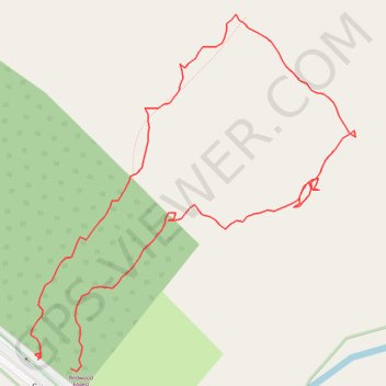
Redwood Forest
- Distance: 0.7 mi
- Elevation gain: 85 ft
- Maximum elevation: 715 ft
- Elevation loss: 89 ft
- Minimum elevation: 646 ft
- Moving time: 26 m 15 s
- Moving speed: 1.5 mph
- Maximum speed: 3.2 mph
- Total time: 53 m
- Global speed: 0.8 mph
Interactive trail map
Trail profile
- Distance: 0.7 mi
- Elevation gain: 85 ft
- Maximum elevation: 715 ft
- Elevation loss: 89 ft
- Minimum elevation: 646 ft
- Moving time: 26 m 15 s
- Moving speed: 1.5 mph
- Maximum speed: 3.2 mph
- Total time: 53 m
- Global speed: 0.8 mph
About this trail
Name: Redwood Forest trail, distance, elevation, map, profile, GPS track
Coordinates: -37.71965 145.75216 -37.71691 145.75531
Other hiking, mountain biking, running and outdoor activity trails
Click on a trail to view its statistics, map and profile.
Tallarook - Eildon - Hurstbridge
Australia > Victoria > Tallarook
#Bike
Distance: 173.2 mi • Elevation gain: 16,066 ft • Maximum elevation: 2,848 ft