Thank you for supporting this site ❤️
Make a donation
Make a donation
Gear up for your next adventure:
As an Amazon Associate, this site earns from qualifying purchases at no extra cost to you.
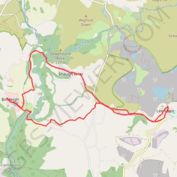
Bickleigh - Lee Moor
- Distance: 10.3 mi
- Elevation gain: 1,207 ft
- Maximum elevation: 758 ft
- Elevation loss: 1,211 ft
- Minimum elevation: 108 ft
- Moving time: 4 h 1 m
- Moving speed: 2.5 mph
- Maximum speed: 8.5 mph
- Total time: 4 h 11 m
- Global speed: 2.4 mph
Interactive trail map
Thank you for supporting this site ❤️
Make a donation
Make a donation
Gear up for your next adventure:
As an Amazon Associate, this site earns from qualifying purchases at no extra cost to you.
Trail profile
- Distance: 10.3 mi
- Elevation gain: 1,207 ft
- Maximum elevation: 758 ft
- Elevation loss: 1,211 ft
- Minimum elevation: 108 ft
- Moving time: 4 h 1 m
- Moving speed: 2.5 mph
- Maximum speed: 8.5 mph
- Total time: 4 h 11 m
- Global speed: 2.4 mph
Thank you for supporting this site ❤️
Make a donation
Make a donation
Gear up for your next adventure:
As an Amazon Associate, this site earns from qualifying purchases at no extra cost to you.
About this trail
Name: Bickleigh - Lee Moor trail, distance, elevation, map, profile, GPS track
Start: Woolwell, Bickleigh, South Hams, Devon, England, PL6 7AF, United Kingdom (50.44237 -4.08598)
End: Woolwell, Bickleigh, South Hams, Devon, England, PL6 7AF, United Kingdom (50.44218 -4.08598)
Coordinates: 50.43413 -4.08598 50.45625 -4.01034
Thank you for supporting this site ❤️
Make a donation
Make a donation
Gear up for your next adventure:
As an Amazon Associate, this site earns from qualifying purchases at no extra cost to you.