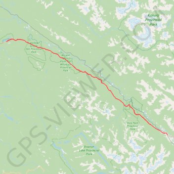
Fraser-Fort George - McBride
#Bike
- Distance: 90.8 mi
- Elevation gain: 4,439 ft
- Maximum elevation: 3,061 ft
- Elevation loss: 4,715 ft
- Minimum elevation: 2,185 ft
Interactive trail map
Trail profile
- Distance: 90.8 mi
- Elevation gain: 4,439 ft
- Maximum elevation: 3,061 ft
- Elevation loss: 4,715 ft
- Minimum elevation: 2,185 ft
About this trail
Name: Fraser-Fort George - McBride trail, distance, elevation, map, profile, GPS track
Coordinates: 53.30966 -121.90853 53.92118 -120.17641