Thank you for supporting this site ❤️
Make a donation
Make a donation
Gear up for your next adventure:
As an Amazon Associate, this site earns from qualifying purchases at no extra cost to you.
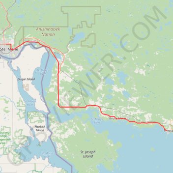
Sault Ste. Marie - Thessalon
Lake Huron. #Bike #SaultSteMarie #Thessalon #Huron
- Distance: 51.8 mi
- Elevation gain: 1,014 ft
- Maximum elevation: 784 ft
- Elevation loss: 1,217 ft
- Minimum elevation: 577 ft
Interactive trail map
Thank you for supporting this site ❤️
Make a donation
Make a donation
Gear up for your next adventure:
As an Amazon Associate, this site earns from qualifying purchases at no extra cost to you.
Trail profile
- Distance: 51.8 mi
- Elevation gain: 1,014 ft
- Maximum elevation: 784 ft
- Elevation loss: 1,217 ft
- Minimum elevation: 577 ft
Thank you for supporting this site ❤️
Make a donation
Make a donation
Gear up for your next adventure:
As an Amazon Associate, this site earns from qualifying purchases at no extra cost to you.
About this trail
Name: Sault Ste. Marie - Thessalon trail, distance, elevation, map, profile, GPS track
Coordinates: 46.26088 -84.30764 46.54607 -83.56668
Thank you for supporting this site ❤️
Make a donation
Make a donation
Gear up for your next adventure:
As an Amazon Associate, this site earns from qualifying purchases at no extra cost to you.
Other hiking, mountain biking, running and outdoor activity trails
Click on a trail to view its statistics, map and profile.