Thank you for supporting this site ❤️
Make a donation
Make a donation
Gear up for your next adventure:
As an Amazon Associate, this site earns from qualifying purchases at no extra cost to you.
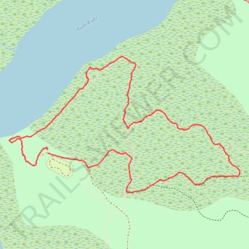
Kathio State Park, MN
- Distance: 3.5 mi
- Elevation gain: 98 ft
- Maximum elevation: 1,309 ft
- Elevation loss: 95 ft
- Minimum elevation: 1,253 ft
- Moving time: 1 h 19 m
- Moving speed: 2.6 mph
- Maximum speed: 6.7 mph
- Total time: 1 h 26 m
- Global speed: 2.4 mph
Interactive trail map
Thank you for supporting this site ❤️
Make a donation
Make a donation
Gear up for your next adventure:
As an Amazon Associate, this site earns from qualifying purchases at no extra cost to you.
Trail profile
- Distance: 3.5 mi
- Elevation gain: 98 ft
- Maximum elevation: 1,309 ft
- Elevation loss: 95 ft
- Minimum elevation: 1,253 ft
- Moving time: 1 h 19 m
- Moving speed: 2.6 mph
- Maximum speed: 6.7 mph
- Total time: 1 h 26 m
- Global speed: 2.4 mph
Thank you for supporting this site ❤️
Make a donation
Make a donation
Gear up for your next adventure:
As an Amazon Associate, this site earns from qualifying purchases at no extra cost to you.
About this trail
Name: Kathio State Park, MN trail, distance, elevation, map, profile, GPS track
Coordinates: 46.14187 -93.77618 46.15090 -93.75414
Topography: Kathio Township topographic map, elevation, terrain
Thank you for supporting this site ❤️
Make a donation
Make a donation
Gear up for your next adventure:
As an Amazon Associate, this site earns from qualifying purchases at no extra cost to you.