Thank you for supporting this site ❤️
Make a donation
Make a donation
Gear up for your next adventure:
As an Amazon Associate, this site earns from qualifying purchases at no extra cost to you.
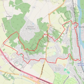
Tédan - Le bois des Bruyères
- Distance: 8.0 mi
- Elevation gain: 830 ft
- Maximum elevation: 561 ft
- Elevation loss: 827 ft
- Minimum elevation: 66 ft
Interactive trail map
Thank you for supporting this site ❤️
Make a donation
Make a donation
Gear up for your next adventure:
As an Amazon Associate, this site earns from qualifying purchases at no extra cost to you.
Trail profile
- Distance: 8.0 mi
- Elevation gain: 830 ft
- Maximum elevation: 561 ft
- Elevation loss: 827 ft
- Minimum elevation: 66 ft
Thank you for supporting this site ❤️
Make a donation
Make a donation
Gear up for your next adventure:
As an Amazon Associate, this site earns from qualifying purchases at no extra cost to you.
About this trail
Name: Tédan - Le bois des Bruyères trail, distance, elevation, map, profile, GPS track
Coordinates: 48.93885 1.95165 48.95626 1.99966
Thank you for supporting this site ❤️
Make a donation
Make a donation
Gear up for your next adventure:
As an Amazon Associate, this site earns from qualifying purchases at no extra cost to you.
Other hiking, mountain biking, running and outdoor activity trails
Click on a trail to view its statistics, map and profile.
Paris - Mantes-la-Jolie
France > Ile-de-France > Hauts-de-Seine > Boulogne-Billancourt > Jardin de la Mairie
Distance: 32.3 mi • Elevation gain: 1,719 ft • Maximum elevation: 610 ft