Make a donation
Gear up for your next adventure:
As an Amazon Associate, this site earns from qualifying purchases at no extra cost to you.
2026-04-14_14-03_Tue
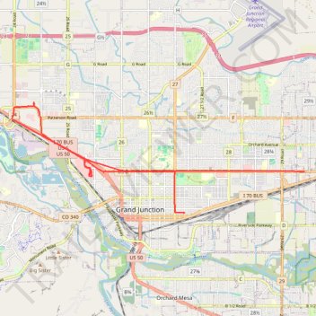
- Distance: 11.8 mi
- Elevation gain: 256 ft
- Maximum elevation: 4,642 ft
- Elevation loss: 295 ft
- Minimum elevation: 4,534 ft
- Moving time: 49 m 38 s
- Moving speed: 14.3 mph
- Maximum speed: 48.4 mph
- Total time: 1 h 35 m
- Global speed: 7.4 mph
Interactive trail map
Make a donation
Gear up for your next adventure:
As an Amazon Associate, this site earns from qualifying purchases at no extra cost to you.
Trail profile
- Distance: 11.8 mi
- Elevation gain: 256 ft
- Maximum elevation: 4,642 ft
- Elevation loss: 295 ft
- Minimum elevation: 4,534 ft
- Moving time: 49 m 38 s
- Moving speed: 14.3 mph
- Maximum speed: 48.4 mph
- Total time: 1 h 35 m
- Global speed: 7.4 mph
Make a donation
Gear up for your next adventure:
As an Amazon Associate, this site earns from qualifying purchases at no extra cost to you.
About this trail
Name: 2026-04-14_14-03_Tue trail, distance, elevation, map, profile, GPS track
Coordinates: 39.06606 -108.60899 39.09576 -108.50745
Topography: Grand Junction topographic map, elevation, terrain
Make a donation
Gear up for your next adventure:
As an Amazon Associate, this site earns from qualifying purchases at no extra cost to you.
Other hiking, mountain biking, running and outdoor activity trails
Click on a trail to view its statistics, map and profile.
2026-04-13_13-38_Mon
United States > Colorado > Mesa County
Distance: 73.9 mi • Elevation gain: 3,074 ft • Maximum elevation: 5,325 ft
2026-04-18_13-27_Sat
United States > Colorado > Mesa County > Clifton
Distance: 14.5 mi • Elevation gain: 299 ft • Maximum elevation: 4,760 ft