Thank you for supporting this site ❤️
Make a donation
Make a donation
Gear up for your next adventure:
As an Amazon Associate, this site earns from qualifying purchases at no extra cost to you.
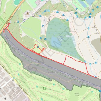
Hansen Dam Southeast
- Distance: 2.3 mi
- Elevation gain: 125 ft
- Maximum elevation: 1,096 ft
- Elevation loss: 125 ft
- Minimum elevation: 1,001 ft
- Moving time: 41 m 1 s
- Moving speed: 3.4 mph
- Maximum speed: 5.8 mph
- Total time: 41 m 1 s
- Global speed: 3.4 mph
Interactive trail map
Thank you for supporting this site ❤️
Make a donation
Make a donation
Gear up for your next adventure:
As an Amazon Associate, this site earns from qualifying purchases at no extra cost to you.
Trail profile
- Distance: 2.3 mi
- Elevation gain: 125 ft
- Maximum elevation: 1,096 ft
- Elevation loss: 125 ft
- Minimum elevation: 1,001 ft
- Moving time: 41 m 1 s
- Moving speed: 3.4 mph
- Maximum speed: 5.8 mph
- Total time: 41 m 1 s
- Global speed: 3.4 mph
Thank you for supporting this site ❤️
Make a donation
Make a donation
Gear up for your next adventure:
As an Amazon Associate, this site earns from qualifying purchases at no extra cost to you.
About this trail
Name: Hansen Dam Southeast trail, distance, elevation, map, profile, GPS track
Coordinates: 34.26184 -118.40020 34.26823 -118.38704
Topography: Los Angeles topographic map, elevation, terrain
Thank you for supporting this site ❤️
Make a donation
Make a donation
Gear up for your next adventure:
As an Amazon Associate, this site earns from qualifying purchases at no extra cost to you.
Other hiking, mountain biking, running and outdoor activity trails
Click on a trail to view its statistics, map and profile.
Hansen Dam Lake loop
United States > California > Los Angeles County > Los Angeles
Distance: 4.0 mi • Elevation gain: 131 ft • Maximum elevation: 1,037 ft