Thank you for supporting this site ❤️
Make a donation
Make a donation
Gear up for your next adventure:
As an Amazon Associate, this site earns from qualifying purchases at no extra cost to you.
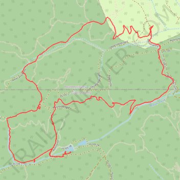
School bus mountain biking route with Mines
- Distance: 6.3 mi
- Elevation gain: 1,119 ft
- Maximum elevation: 9,475 ft
- Elevation loss: 1,125 ft
- Minimum elevation: 8,642 ft
- Moving time: 2 h 22 m
- Moving speed: 2.7 mph
- Maximum speed: 5.2 mph
- Total time: 2 h 59 m
- Global speed: 2.1 mph
Interactive trail map
Thank you for supporting this site ❤️
Make a donation
Make a donation
Gear up for your next adventure:
As an Amazon Associate, this site earns from qualifying purchases at no extra cost to you.
Trail profile
- Distance: 6.3 mi
- Elevation gain: 1,119 ft
- Maximum elevation: 9,475 ft
- Elevation loss: 1,125 ft
- Minimum elevation: 8,642 ft
- Moving time: 2 h 22 m
- Moving speed: 2.7 mph
- Maximum speed: 5.2 mph
- Total time: 2 h 59 m
- Global speed: 2.1 mph
Thank you for supporting this site ❤️
Make a donation
Make a donation
Gear up for your next adventure:
As an Amazon Associate, this site earns from qualifying purchases at no extra cost to you.
About this trail
Name: School bus mountain biking route with Mines trail, distance, elevation, map, profile, GPS track
Coordinates: 39.92430 -105.54446 39.94026 -105.52066
Topography: West Magnolia Campground topographic map, elevation, terrain
Thank you for supporting this site ❤️
Make a donation
Make a donation
Gear up for your next adventure:
As an Amazon Associate, this site earns from qualifying purchases at no extra cost to you.