Glynllifon Survey
Gwynedd Walking
- Distance: 2.2 mi
- Elevation gain: 118 ft
- Maximum elevation: 187 ft
- Elevation loss: 118 ft
- Minimum elevation: 105 ft
- Moving time: 1 h 30 s
- Moving speed: 2.2 mph
- Maximum speed: 3.5 mph
- Total time: 1 h 21 m
- Global speed: 1.6 mph
Interactive trail map
Trail profile
- Distance: 2.2 mi
- Elevation gain: 118 ft
- Maximum elevation: 187 ft
- Elevation loss: 118 ft
- Minimum elevation: 105 ft
- Moving time: 1 h 30 s
- Moving speed: 2.2 mph
- Maximum speed: 3.5 mph
- Total time: 1 h 21 m
- Global speed: 1.6 mph
About this trail
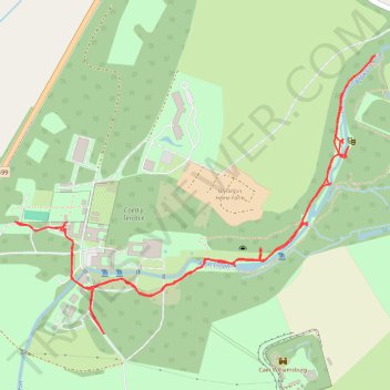
Name: Glynllifon Survey trail, distance, elevation, map, profile, GPS track
Coordinates: 53.07140 -4.31012 53.07782 -4.29630
Other hiking, mountain biking, running and outdoor activity trails
Click on a trail to view its statistics, map and profile.
Glynllifon Park path network
United Kingdom > Wales > Gwynedd > Groeslon > Bethesda-bach
Distance: 2.1 mi • Elevation gain: 187 ft • Maximum elevation: 190 ft