Thank you for supporting this site ❤️
Make a donation
Make a donation
Gear up for your next adventure:
As an Amazon Associate, this site earns from qualifying purchases at no extra cost to you.
Edge of field and woods
- Distance: 0.5 mi
- Elevation gain: 30 ft
- Maximum elevation: 174 ft
- Elevation loss: 23 ft
- Minimum elevation: 151 ft
- Moving time: 11 m 45 s
- Moving speed: 2.4 mph
- Maximum speed: 4.7 mph
- Total time: 14 m 3 s
- Global speed: 2.0 mph
Interactive trail map
Thank you for supporting this site ❤️
Make a donation
Make a donation
Gear up for your next adventure:
As an Amazon Associate, this site earns from qualifying purchases at no extra cost to you.
Trail profile
- Distance: 0.5 mi
- Elevation gain: 30 ft
- Maximum elevation: 174 ft
- Elevation loss: 23 ft
- Minimum elevation: 151 ft
- Moving time: 11 m 45 s
- Moving speed: 2.4 mph
- Maximum speed: 4.7 mph
- Total time: 14 m 3 s
- Global speed: 2.0 mph
Thank you for supporting this site ❤️
Make a donation
Make a donation
Gear up for your next adventure:
As an Amazon Associate, this site earns from qualifying purchases at no extra cost to you.
About this trail
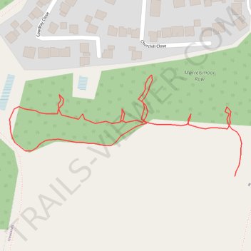
Name: Edge of field and woods trail, distance, elevation, map, profile, GPS track
Start: Newlands, Winchester, Hampshire, England, PO7 5RT, United Kingdom (50.86944 -1.04824)
Coordinates: 50.86944 -1.05163 50.87040 -1.04814
Thank you for supporting this site ❤️
Make a donation
Make a donation
Gear up for your next adventure:
As an Amazon Associate, this site earns from qualifying purchases at no extra cost to you.