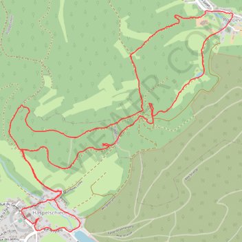
Balade entre Haspelschiedt et Roppeviller
- Distance: 5.8 mi
- Elevation gain: 892 ft
- Maximum elevation: 1,299 ft
- Elevation loss: 889 ft
- Minimum elevation: 886 ft
- Moving time: 8 h 37 m
- Moving speed: 0.7 mph
- Maximum speed: 3.2 mph
- Total time: 8 h 58 m
- Global speed: 0.6 mph
Interactive trail map
Trail profile
- Distance: 5.8 mi
- Elevation gain: 892 ft
- Maximum elevation: 1,299 ft
- Elevation loss: 889 ft
- Minimum elevation: 886 ft
- Moving time: 8 h 37 m
- Moving speed: 0.7 mph
- Maximum speed: 3.2 mph
- Total time: 8 h 58 m
- Global speed: 0.6 mph
About this trail
Name: Balade entre Haspelschiedt et Roppeviller trail, distance, elevation, map, profile, GPS track
Coordinates: 49.08564 7.48225 49.10225 7.50791
Other hiking, mountain biking, running and outdoor activity trails
Click on a trail to view its statistics, map and profile.
Track vom: 2020-06-13 07:00
Germany > North Rhine-Westphalia > Kreis Wesel > Schermbeck
Distance: 422.5 mi • Elevation gain: 17,392 ft • Maximum elevation: 3,022 ft
Track vom: 2020-06-27 07:26
Germany > Bavaria > Landkreis Ostallgäu > Halblech
Distance: 427.6 mi • Elevation gain: 14,131 ft • Maximum elevation: 2,989 ft
Riethoven naar Oostenrijk
Netherlands > North Brabant > Riethoven > Eind
Distance: 573.0 mi • Elevation gain: 44,715 ft • Maximum elevation: 6,224 ft
Eurovelo 15 - Strasbourg Rotterdam
France > Grand Est > Bas-Rhin > Strasbourg
Distance: 554.1 mi • Elevation gain: 6,903 ft • Maximum elevation: 479 ft
PT23BS1 Kiel → Lörrach
Germany > Schleswig-Holstein > Kiel
Distance: 650.4 mi • Elevation gain: 30,397 ft • Maximum elevation: 2,484 ft