Make a donation
Gear up for your next adventure:
As an Amazon Associate, this site earns from qualifying purchases at no extra cost to you.
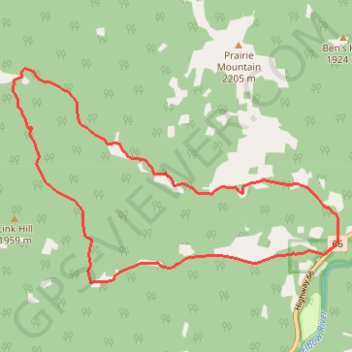
Powderface Creek - Prairie Creek
Interactive trail map
Make a donation
Gear up for your next adventure:
As an Amazon Associate, this site earns from qualifying purchases at no extra cost to you.
Trail profile
- Distance: 7.4 mi
- Elevation gain: 1,161 ft
- Maximum elevation: 5,774 ft
- Elevation loss: 1,161 ft
- Minimum elevation: 4,951 ft
Make a donation
Gear up for your next adventure:
As an Amazon Associate, this site earns from qualifying purchases at no extra cost to you.
About this trail
Name: Powderface Creek - Prairie Creek trail, distance, elevation, map, profile, GPS track
Start: Prairie Mountain, Kananaskis Improvement District, Alberta, Canada (50.86650 -114.78898)
End: Prairie Mountain, Kananaskis Improvement District, Alberta, Canada (50.86650 -114.78898)
Coordinates: 50.86192 -114.84644 50.88583 -114.78885
Make a donation
Gear up for your next adventure:
As an Amazon Associate, this site earns from qualifying purchases at no extra cost to you.
Other hiking, mountain biking, running and outdoor activity trails
Click on a trail to view its statistics, map and profile.
Prairie Mountain
Canada > Alberta > Kananaskis Improvement District
Kananaskis Country Public Land Use Zone. #Hiking #Kananaskis
Distance: 4.1 mi • Elevation gain: 2,247 ft • Maximum elevation: 7,201 ft