Make a donation
Gear up for your next adventure:
As an Amazon Associate, this site earns from qualifying purchases at no extra cost to you.
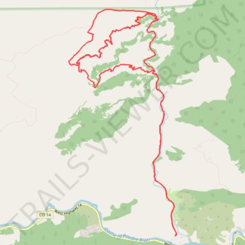
Hewlett Gulch Loop Trail - Roosevelt National Forest
- Distance: 12.4 mi
- Elevation gain: 1,903 ft
- Maximum elevation: 6,801 ft
- Elevation loss: 1,906 ft
- Minimum elevation: 5,728 ft
- Moving time: 2 h 43 s
- Moving speed: 6.2 mph
- Maximum speed: 23.4 mph
- Total time: 2 h 43 m
- Global speed: 4.6 mph
Interactive trail map
Make a donation
Gear up for your next adventure:
As an Amazon Associate, this site earns from qualifying purchases at no extra cost to you.
Trail profile
- Distance: 12.4 mi
- Elevation gain: 1,903 ft
- Maximum elevation: 6,801 ft
- Elevation loss: 1,906 ft
- Minimum elevation: 5,728 ft
- Moving time: 2 h 43 s
- Moving speed: 6.2 mph
- Maximum speed: 23.4 mph
- Total time: 2 h 43 m
- Global speed: 4.6 mph
Make a donation
Gear up for your next adventure:
As an Amazon Associate, this site earns from qualifying purchases at no extra cost to you.
About this trail
Name: Hewlett Gulch Loop Trail - Roosevelt National Forest trail, distance, elevation, map, profile, GPS track
Start: Hewlett Gulch Road, Poudre Park, Larimer County, Colorado, United States (40.68913 -105.31059)
End: Hewlett Gulch Road, Poudre Park, Larimer County, Colorado, United States (40.68912 -105.31058)
Coordinates: 40.68912 -105.33256 40.72460 -105.31030
Topography: Larimer County topographic map, elevation, terrain
Make a donation
Gear up for your next adventure:
As an Amazon Associate, this site earns from qualifying purchases at no extra cost to you.